Previous Post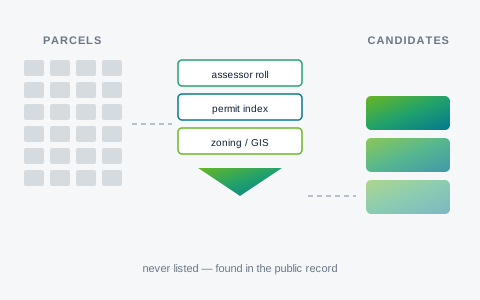
- August 18, 2026
Why the Best LIHTC Sites Never Hit the MLS
If you're underwriting a site on a commercial corridor and you don't yet know its distance to the nearest major transit stop, you're not done underwriting it. Under AB 2011, that distance can swing your achievable unit count by 20 units per acre and your height limit by 20 feet — before you've sketched a single unit plan.
AB 2011, the Affordable Housing and High Road Jobs Act of 2022, is codified at Government Code Section 65912.100 et seq. It's one of the more consequential streamlining statutes to hit commercially-zoned land in years, and its density math is worth understanding in detail, because it's not a flat bonus. It's a tiered system, and the tier you land in depends on a transit test most developers aren't checking early enough.
The core mechanism is straightforward: a qualifying multifamily or mixed-income housing project on a commercially-zoned site gets ministerial approval. No discretionary hearing, no planning commission vote, no CEQA review. If the project meets the statute's objective standards, the local agency has to approve it administratively.
That's a real shift in entitlement risk. Discretionary review is where projects die or get value-engineered into the ground over months of hearings. Ministerial approval under AB 2011 removes that exposure entirely for eligible sites — which is exactly why the density and height limits attached to it matter so much. They define what you're actually allowed to build without ever facing a hearing.
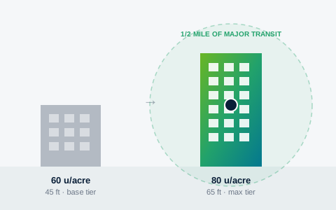
AB 2011 sets its density and height ceilings on a sliding scale tied to real, mapped transit proximity — not a flat statewide number. A qualifying mixed-income project on a wide commercial corridor with no transit nearby tops out around 60 units per acre and 45 feet.
Move that same site within a half mile of a major transit stop or a high-quality transit corridor, and the ceiling jumps to as much as 80 units per acre, with height climbing to 65 feet in larger non-coastal cities. That's the statute's maximum tier — and the difference between the two tiers isn't a marginal adjustment. It's the difference between a project that pencils at a certain land basis and one that doesn't.
For a feasibility analyst, that means the transit question isn't a design consideration you get to later. It's a threshold input that determines which density tier you're even modeling against.
Here's the part that trips people up: AB 2011's "major transit stop" and "high-quality transit corridor" language isn't a bespoke definition invented for this statute. It's the same test already defined in Public Resources Code Sections 21155, 21064.3, and 21060.2 — the definitions that underlie the High-Quality Transit Area, or HQTA, designation that Caltrans and regional agencies already maintain and publish.
In practice, that means you're not waiting on a new dataset or a new agency determination to know which tier a parcel falls into. If a parcel is inside an existing HQTA boundary, it clears the AB 2011 transit test for the maximum density and height tier. If it's outside, you're working with the base commercial-corridor tier. The regulatory plumbing is already public record — the work is just connecting it to the parcel.
Consider two otherwise identical commercially-zoned parcels a few blocks apart — same zoning designation, same lot size, same corridor. One sits inside a half-mile HQTA buffer. The other doesn't. On paper they look like the same opportunity. Run the AB 2011 numbers and they aren't: one supports up to 80 units per acre at 65 feet, ministerially approved, no CEQA exposure. The other tops out at 60 units per acre and 45 feet under the same ministerial path.
That gap changes unit count, which changes total development cost, which changes the debt and equity you need to raise, which changes whether the deal clears your return threshold at all. Getting the transit answer wrong — or not getting it until late in due diligence — means redoing pro forma work that should have been settled in the first hour of site screening.
Because the AB 2011 transit test and the HQTA determination are the exact same underlying statutory test, EZFeasi's Parcel Search derives AB 2011 max-density-tier eligibility directly from a parcel's existing HQTA signal, rather than maintaining a separate transit layer. It's a small example of a broader pattern in feasibility work: one well-sourced public-record layer often answers more than one eligibility question, if you know where the statutes actually point back to the same map.
Use the applicable agency documents and funding-year requirements when evaluating a project.
Topic: