Previous Post
- August 18, 2026
Reading the Sources & Uses Stack: A Primer for LIHTC Deals
Every LIHTC developer we talk to has looked at the same three listing sites and found the same three parcels that six other developers already have under LOI. That's not a sourcing strategy. That's a queue.
The sites that actually pencil for 9% or 4% credit deals rarely show up on a for-sale sign, because the owner isn't trying to sell yet. If you want those parcels before your competitors find them, you have to go around the MLS, not through it.
By the time land hits a commercial listing site, it's gone through a filter you don't control. The owner has decided to sell, hired a broker, set a price, and started fielding calls. Every developer with a Costar login or a broker relationship sees it at the same moment you do. Whatever premium existed for being first is already gone.
That's not a knock on listed deals — some of them are good. But treating the listing site as your primary sourcing tool means you're only ever looking at the subset of parcels whose owners have already decided to monetize. The much larger set of sites that would work for a LIHTC deal — zoned right, sized right, located near the amenities CTCAC scores for — sits outside that subset entirely, because most owners of good underutilized land aren't spending money to advertise it.
That's the actual logic of off-market sourcing. An owner who isn't actively marketing a parcel usually isn't the one paying a broker to list it. So the way you find that owner isn't by watching for a listing — it's by watching the parcel itself.
Motivated-seller signals show up in public records well before they show up as a for-sale sign, and they're consistent enough to screen for systematically. A parcel with no recent building-permit activity on a site that's clearly capable of supporting more. An owner who has held vacant or underutilized land for years without developing it — sometimes a family estate, sometimes a business that outgrew its need for the extra acreage, sometimes a straightforward land-bank position. A site that's underbuilt relative to its own zoning, like a single-story use sitting on a parcel entitled for multifamily density.
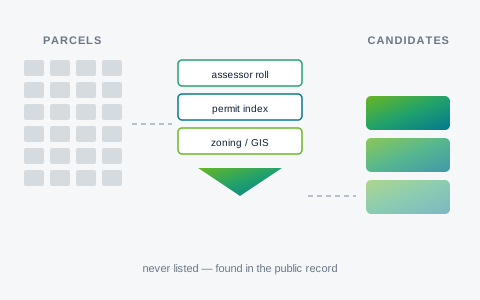
None of that is visible from a listing site, because none of it required the owner to do anything. It's visible from cross-referencing the county assessor roll, the permit index, and the zoning or GIS layer against each other — the same three sources, checked against one another, over and over, across a target area. A parcel that's been assessed the same way for a decade, has no permit history, and sits in a zone that allows three times its current use is a very different lead than a parcel that just got listed at market price after a bidding process.
This is mechanical work. It's also exactly the kind of work that rewards doing it at scale across a county rather than parcel by parcel, because the signal is only useful in aggregate — you're not looking for one perfect site, you're ranking hundreds of candidates against each other.
There's a real limit here, and it's worth naming precisely. The bulk parcel and GIS data California counties publish for download generally carries geometry, situs address, land use, and assessed characteristics — but not owner-of-record name or contact information. Most counties keep that behind their own assessor lookup, or license it commercially. So a public-records sourcing workflow can rank a parcel, evidence why it's suitable — zoning headroom, distance to transit and amenities, the CTCAC/CDLAC-relevant signals a site carries — and tell you it's worth pursuing. It cannot hand you the owner's name or a phone number.
That's a practical boundary in how the data is published, not a legal prohibition on knowing who owns a parcel — ownership is a matter of public record, and the recorded deed is public. (The one genuine statutory restriction here is narrow: Government Code Section 7928.205, which since AB 1785 took effect in 2025 bars agencies from posting the name and assessor parcel number tied to the home address of an elected or appointed official. It applies to officials, not to property owners generally.) The workflow's job is to narrow a county's worth of parcels down to a short list that's actually worth the time to chase. The next step — getting the owner's identity — happens through the county's own assessor or recorder system, looked up directly by APN. That's a five-minute step once you already know which APN is worth the five minutes.
Keeping those two steps separate is the point. Screening thousands of parcels for suitability signals is a data problem. Getting one owner's contact information for a parcel you've already decided is worth pursuing is a records-lookup problem. Conflating them is how a lot of sourcing tools either overpromise or quietly step outside what the public record actually allows.
This is the workflow EZFeasi's Parcel Search runs today, not as a hypothetical. It scores real, public-record parcel data — live in Riverside and San Diego counties as of this writing, with Orange, Los Angeles, San Bernardino and Imperial in the ingest pipeline — against 17 CTCAC, CDLAC, and HUD-relevant signals, so you can filter down to parcels that already look development-ready on paper before you spend a single outreach call chasing an owner. From there, the APN lookup through the county's own assessor system is the natural next click.
Use the applicable agency documents and funding-year requirements when evaluating a project.
Topic: