Previous Post
- August 26, 2026
How to Read a State QAP Competitive Scoring Rubric Before You Apply
A parcel doesn't do anything to lose its basis boost. It just sits there while HUD recalculates the list around it. Every QCT and DDA determination a sponsor relies on for the 130% eligible-basis increase under IRC Section 42(d)(5)(B) comes from a list HUD rebuilds, in full, once a year — and the rebuild runs on new income, poverty, and rent data, not on anything that happened at the site.
That matters everywhere the credit gets used, not only in the California markets this site has covered before. The mechanism is federal, the republication cycle is federal, and the annual reshuffling it produces touches every state, territory, and deal type using 9% or 4% credits. Here's how the cycle actually runs, what moved nationwide in the most recent republication, and why a sponsor working more than one state needs a single check, not fifty separate ones.
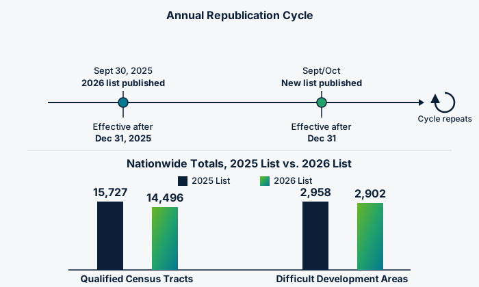
HUD says this plainly in its own Federal Register notice: "The United States Department of Housing and Urban Development (HUD) makes new DDA and QCT designations annually." The statutory basis sits in IRC Section 42(d)(5)(B)(ii)(I) for QCTs and Section 42(d)(5)(B)(iii)(I) for DDAs, which direct HUD's Secretary to designate both. In practice, HUD publishes a new notice in the Federal Register every September or October — September 30, 2025 for the 2026 list, September 9, 2024 for 2025, September 21, 2023 for 2024, October 25, 2022 for 2023 — and each year's list takes effect for credit allocations made, or, for tax-exempt bond deals under Section 42(h)(4), for bonds issued and buildings placed in service, after December 31 of that year. Current-year lists — the metro and non-metro DDA rosters, the geocoded QCT tract file, the underlying data workbook — publish at huduser.gov/portal/datasets/qct.html, with an interactive lookup at huduser.gov/portal/sadda/sadda_qct.html.
What that rebuild actually moved this cycle is a real number, not an abstraction. Queried directly against HUD's own ArcGIS feature service, the 2026 list carries 14,496 qualified census tracts and 2,902 DDAs nationwide. The 2025 list carried 15,727 tracts and 2,958 DDAs. That's 1,231 fewer qualifying tracts — about 7.8% — and 56 fewer DDAs — about 1.9% — in a single publication cycle, nationwide, with no tract or ZIP code tabulation area changing its boundary in between.
DDA status isn't a fixed cost threshold a ZIP code tabulation area (ZCTA) either clears or doesn't. HUD compares each area's rents — Small Area Fair Market Rents for metro ZCTAs, county-level FMRs outside metro areas — against income limits set at 50% of area median gross income, ranks every candidate area by that ratio, and designates down the list until it hits a population cap. That cap, under Section 42(d)(5)(B)(iii), is set nationally: the combined population of every ZCTA HUD designates as a metro DDA can't exceed 20% of the total population living in metro areas nationwide, and the same 20% ceiling applies separately, and nationally, to non-metro DDAs. A ZCTA's status this year depends on how its rent-to-income ratio ranked against every other ZCTA in the country competing for the same capped slots — not on whether it cleared some fixed number in isolation.
QCTs move for a related but distinct reason. Poverty rate and the 60%-of-AMGI income threshold get recalculated every year against new American Community Survey data — HUD blends the three most recent 5-year ACS releases specifically so one year's sampling noise doesn't flip a tract's status on its own — and the population cap here, under Section 42(d)(5)(B)(ii)(III), applies per metro area rather than as one national pool. Either way, the underlying fact is the same: eligibility is a moving comparison against updated data and against every other candidate area, recalculated from scratch each year, not a box a site checks once and keeps checked.
The 2026 notice designates DDAs, in its own words, "for each of the 50 states, the District of Columbia, Puerto Rico, American Samoa, Guam, the Northern Mariana Islands, and the U.S. Virgin Islands." QCTs follow the same national footprint. This isn't a program that behaves differently by state — the 130% eligible-basis math under Section 42(d)(5)(B) is identical whether the parcel sits in a Riverside County ZCTA or one in Ohio, Texas, or rural Montana. What varies by state is everything layered on top of that federal number: each state's own QAP scoring, its soft-fund stack, its allocation timeline.
For a sponsor sourcing sites across more than one state, that's the practical payoff of understanding the cycle this way. The basis-boost check itself doesn't need fifty separate playbooks. It needs one federal check, repeated identically against whichever year's HUD list is currently in effect, regardless of which state's QAP governs the rest of the underwriting.
HUD's notice anticipates the exact problem an annual rebuild creates and builds in a transition rule. If a site sat in a QCT or DDA on the date a complete application was filed with the allocating or bond-issuing agency, the deal can still claim the boost even after a later year's list drops that site — as long as credits are allocated, or bonds are issued and the building placed in service, within 730 days of that filing date. HUD's notice works through this with a set of interpretive examples: file while the site is designated, close within the 730-day window, and the boost holds even though the current map no longer shows the site as qualified.
The cushion only protects a status that actually existed on the filing date, and it starts a clock tied to that specific date — not to site control, not to an LOI, not to when underwriting began. A site that qualified two cycles before a sponsor gets around to filing doesn't get carried forward automatically; the designation has to be live, on the list in effect, on the day the application is deemed complete.
This is exactly the check that doesn't hold still, which is why EZFeasi's Basis Boost Map pulls the designations directly from HUD's own versioned feature services rather than a static export. The map is running the 2026 vintage today — the same 14,496 tracts and 2,902 DDAs confirmed above, effective for allocations after December 31, 2025 — as a nationwide choropleth of qualified-tract density by state. Drill into any state and it shows the real QCT tracts and DDA areas, including the non-metro DDAs HUD designates by whole county, not just the county where one particular deal happens to sit.
That nationwide view and Parcel Search's parcel-level signal aren't the same tool doing the same job, and they don't need to be. Parcel Search scores individual parcels against QCT/DDA status alongside 16 other site-suitability signals, live today in Riverside and San Diego counties. The Basis Boost Map is the wider check: wherever a site search moves next — any state, any county — it's reading against the same current HUD publication, not last year's list or a screenshot from whenever the map was last rebuilt.
Use the applicable agency documents and funding-year requirements when evaluating a project.
Topic: