Previous Post
- August 26, 2026
The QCT/DDA Refresh: Why HUD Redraws the Basis-Boost Map Every Year

Screen a parcel for a LIHTC deal by hand and you're actually running four separate investigations that nobody thinks to separate: what the zoning and state density law actually let you build, how the site would score if it landed in a competitive round, which CTCAC-relevant amenities sit close enough to count, and whether the parcel itself is even large enough, or clear of fire hazard exposure, to support a project at all. Most predevelopment teams run those four investigations across four different spreadsheets, at different points in the process, often after a site is already under an LOI.
EZFeasi's Parcel Search runs all four at once. It scores every candidate parcel against 16 real site-suitability signals, sourced to CTCAC, CDLAC, HUD, CAL FIRE and other public records, the moment a parcel enters a county's screening set. (Parcel Search also carries one motivated-seller signal — stalled permit activity, read off the local building department's permit index — but that's a different question from suitability, and it isn't this piece's subject.) What follows is the full 16-signal roster, grouped the way an underwriter actually reads a site rather than the alphabetical order a database table would give you.
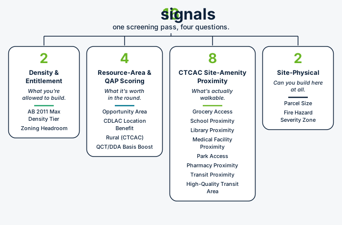
The 16 signals split cleanly into four groups, and each group answers a different question about the same piece of dirt. Two signals — AB 2011 Max Density Tier and Zoning Headroom — test density and entitlement: what you're actually allowed to build, and under what approval path. Four signals — Opportunity Area, CDLAC Location Benefit, Rural (CTCAC), and QCT/DDA Basis Boost — test resource-area and QAP scoring standing: how the site would score, or what basis boost it carries, in a competitive round. Eight signals — Grocery Access, School Proximity, Library Proximity, Medical Facility Proximity, Park Access, Pharmacy Proximity, Transit Proximity, and High-Quality Transit Area — test CTCAC site-amenity proximity: what's actually within walking or transit distance of the parcel. And two signals — Parcel Size and Fire Hazard Severity Zone — test site-physical viability: whether the parcel itself, independent of everything around it, can support a multifamily building at all.
No single signal decides a site's fate, which is the point of running all 16 together instead of checking one and calling it done. A parcel can clear every signal in the proximity group and still fail on parcel size. A parcel can sit inside a Highest Resource opportunity area and still be zoned for half the density a site three blocks away gets under AB 2011. The four groups are independent axes, not one composite score, and a site worth pursuing generally needs to clear enough of each group — not just look good on whichever signal happens to be the most familiar one to check.
AB 2011 Max Density Tier flags whether a parcel qualifies for the statute's highest density and height tier — up to 80 units per acre and 65 feet in larger non-coastal cities, against a 60-unit-per-acre, 45-foot base tier for sites without qualifying transit access — under Government Code Section 65912.100 et seq. The gating question is transit distance, and because AB 2011's transit test reuses the same underlying statutory definitions that drive California's High-Quality Transit Area designation, Parcel Search reads this signal directly off a parcel's existing HQTA status rather than maintaining a separate transit layer. We've covered the tier math and the transit test in more detail in a separate piece on AB 2011.
Zoning Headroom is the more basic entitlement question: is the parcel zoned for multifamily use at all, and if so, is the current improvement sitting well below the unit count that zoning would actually allow. A single-story use on a parcel entitled for several times its current density is exactly the kind of headroom this signal is built to catch, pulled from county zoning records rather than a guess based on the neighborhood. Between the two signals, Zoning Headroom tells you the baseline the local zoning code allows, and AB 2011 Max Density Tier tells you whether state law pushes that baseline higher on a ministerial path that skips discretionary review entirely.
Opportunity Area checks whether the parcel sits in a CTCAC/HCD-designated Highest Resource or High Resource tract, out of the five categories — Highest Resource, High Resource, Moderate Resource, Low Resource, and High Segregation & Poverty — that the CTCAC/HCD Opportunity Map sorts every California census tract into. Where a site lands on that map matters directly for competitive scoring. CDLAC Location Benefit checks a related but separate question: whether the parcel clears the distance-band test behind CDLAC's Location Benefit tiebreaker component under 4 CCR Section 5231(g), measured against the same site-amenity distance standards CTCAC uses rather than against the Opportunity Map itself.
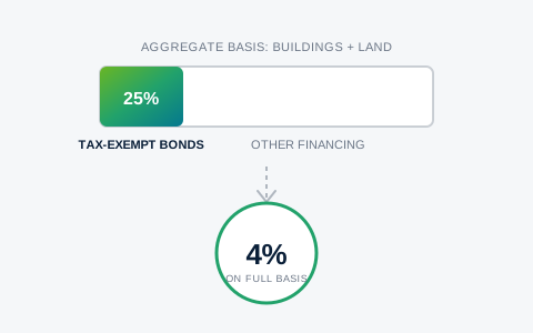
Rural (CTCAC) checks the parcel against the three independent tests under California Health and Safety Code Section 50199.21(a) — USDA Rural Development eligibility, non-metro county status, or a small-incorporated-city test — any one of which opens a separate 20 percent set-aside of the state's 9 percent credit ceiling and loosens the site-amenity distance thresholds elsewhere on this list. QCT/DDA Basis Boost checks HUD's Qualified Census Tract and Difficult Development Area designations, either of which boosts eligible basis to 130% under Internal Revenue Code Section 42(d)(5)(B). We've written full breakdowns of both the Rural test and the QCT/DDA math elsewhere on this site, since each one is deep enough to deserve its own treatment; the short version here is that both signals answer a financial or competitive-scoring question, not a physical one — a site can carry either designation regardless of what's built on it today.
Six of these eight signals map directly onto the site-amenity categories CTCAC scores under 4 CCR Section 10325(c)(4)(A): Grocery Access against the USDA SNAP Retailer Locator, School Proximity against the California Department of Education's school directory, Library Proximity against the IMLS Public Libraries Survey, Medical Facility Proximity against HRSA's Health Center Program data, Park Access against the California Protected Areas Database, and Pharmacy Proximity against OpenStreetMap point-of-interest data. We've broken down the distance thresholds and qualifying definitions behind those six in a separate deep dive on CTCAC Site Amenities scoring elsewhere on this site — the short version for this roster is that each one is a real, sourced check against the actual qualifying definition, not just a straight-line distance on a map, because a grocery store under 25,000 square feet or a clinic that doesn't take Medi-Cal doesn't count no matter how close it sits.
Transit Proximity and High-Quality Transit Area sit in the same proximity family but test something adjacent rather than one of those six categories directly. Transit Proximity checks whether the parcel is within a half mile of a transit stop running 15-minute or better weekday headway, pulled from the regional transit agency's own GTFS feed. High-Quality Transit Area checks whether the parcel falls inside a mapped HQTA boundary, maintained by SCAG or MTC depending on region — a designation that matters beyond this scoring category too, since it's also what feeds the AB 2011 density tier and touches CEQA streamlining and Density Bonus law eligibility. Both signals answer the same underlying question, whether a resident can get around without a car, from two different regulatory angles.
Parcel Size and Fire Hazard Severity Zone are the two signals that don't care about the surrounding neighborhood at all — they're about the parcel itself. Parcel Size checks the county assessor's own GIS records against a roughly half-acre practical floor for viable multifamily site assembly; below that, per-unit soft costs and site-plan constraints tend to make a deal not worth chasing regardless of how everything else scores. Fire Hazard Severity Zone flags whether CAL FIRE has classified the parcel inside a fire hazard severity zone under Public Resources Code Sections 4201 through 4204 — mapped at 14 CCR Section 1280 — which triggers added wildland-urban-interface construction requirements under California Building Code Chapter 7A and can restrict some funding sources outright.
Both signals are checks a site can fail cleanly, independent of density, resource area, or amenities, which is exactly why they sit in their own group. A parcel can be zoned right, sit in a Highest Resource tract, and be a five-minute walk from a grocery store and a transit stop, and still be too small to assemble a viable building envelope, or sit inside a zone that adds a construction-cost premium and a financing constraint that none of the other three groups would have caught.
This is the actual roster Parcel Search screens, live today against real parcel data in Riverside and San Diego counties — not a mockup of what a scoring tool might check, but the same 16 signals, sourced to the same public records described above, applied to every parcel in scope before a developer spends an hour underwriting it. A parcel that clears enough of all four groups is worth sending into a full feasibility study; one that fails cleanly on parcel size or sits well outside every resource and amenity signal is worth knowing about before the LOI, not after months of underwriting work built on a site that was never going to score the way it looked. That's the actual value of running the roster as one pass instead of four separate spreadsheets: the answer to whether a site is worth pursuing shows up at the screening stage, where it's cheap to be wrong, instead of after the site is already under control.
Use the applicable agency documents and funding-year requirements when evaluating a project.
Topic: